

The Live Earth Map & GPS Tracker application by DN Solutions, is an ambitious geospatial utility that attempts to merge terrestrial navigation with astronomical exploration. It is designed for "armchair travelers" and families who require both global imagery and personal tracking capabilities in a single interface.
Functional Breakdown and Integrated Utilities
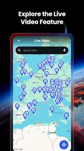
What differentiates this app from standard mapping services is its multi-layer data approach. The standout feature is the "Sky Map," an augmented reality (AR) tool that uses the device's GPS and gyroscope to identify stars, planets, and constellations in real-time. This transforms the app from a simple navigation tool into an educational platform for stargazing. On the terrestrial side, the app offers "Live Global Cameras," providing users with real-time views from public webcams at famous landmarks, beaches, and city centers worldwide.
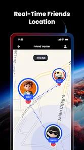
The "Friend Tracker" feature is another significant functional pillar. By utilizing unique shared codes, family members can monitor each other's locations on a 3D interactive map. This is supplemented by a "Speed Map Limit" display for driving safety and a "GPS Geotagged Camera" that pins photos directly to the map. Technically, the app attempts to be a "Swiss Army Knife" of location-based services, although this high feature density often comes at the cost of technical stability and high advertisement frequency.
Insights into the developer’s strategy suggest a "freemium" model where basic satellite views and cameras are available with ad support, while premium features—such as the full 3D Earth terrain and an ad-free experience—require a subscription. However, the aggressive nature of the advertising (sometimes up to eight ads before app entry) has become a primary point of friction for the user base.
Pros
The Sky Map feature is an excellent educational tool for identifying celestial bodies in real-time.
Friend tracking via unique codes provides a secure way for families to monitor safety during travel.
Integrated global webcams offer a unique window into the world’s most famous locations.
The Speed Map Limit feature assists in maintaining road safety by displaying real-time limits.
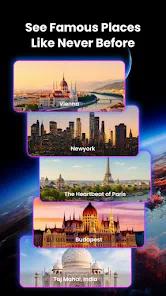
High-resolution 3D satellite imagery provides an immersive way to explore remote landscapes.
The map-integrated gallery allows users to visualize their travels through geotagged photos.
Cons
The volume of advertisements is considered excessive by a large portion of the user base.
Some users report that the underlying maps are outdated and do not reflect recent urban developments.
Technical instability often causes the app to freeze on ad-loading screens or fail to load camera feeds.
FAQs
Identification of stars generally requires GPS, but a data connection is needed for detailed astronomical info.
You must generate a unique code in the app and send it to your friend to enter in their version.
Yes, though they are dependent on the third-party source's uptime; some may experience lag.
There is a free version with ads, but users must be careful with subscription pop-ups for the premium tier.
It provides navigation tools, though it is more optimized for exploration and location tracking.
Hot Reviews
Identification of stars generally requires GPS, but a data connection is needed for detailed astronomical info.
You must generate a unique code in the app and send it to your friend to enter in their version.
Yes, though they are dependent on the third-party source's uptime; some may experience lag.
There is a free version with ads, but users must be careful with subscription pop-ups for the premium tier.
It provides navigation tools, though it is more optimized for exploration and location tracking.