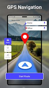
The GPS Navigation & Map Direction application, developed by Entertaining Logix Apps (and often associated with Sharp Apps Studio in various distributions), represents a specialized entry into the travel and local utility sector. With a download footprint exceeding 10 million users, the application targets a demographic that requires a robust, all-in-one travel toolkit rather than a singular mapping interface. The application’s core architecture is built around a multi-modal route planner that supports automobile, truck, bicycle, and pedestrian navigation, leveraging real-time satellite data to provide "shortest path" optimization.
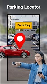
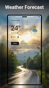
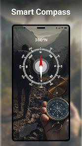
A deep functional disassembly reveals that the application’s primary differentiator is its integration of secondary travel utilities within the navigation flow. This package prioritizes the immediate needs of the driver and international traveler. The inclusion of a digital GPS speedometer is a critical safety feature, allowing users to monitor their velocity and set speed limits, which is particularly useful in unfamiliar jurisdictions where speed traps or changing limits are common. Furthermore, the application integrates a global currency converter utilizing live exchange rates, a live weather forecast module, and a smart parking locator. This architectural choice suggests a strategic attempt to capture the "tourist" and "professional commuter" segments by minimizing the need to switch between multiple specialized apps during a journey.
In comparison to high-fidelity mapping services, this application maintains a significantly lower resource footprint. Its file size has historically ranged from 8.5MB to approximately 43.5MB, depending on the version and optimization for specific Android APIs. This efficiency makes it a premier choice for users in emerging markets or those utilizing mid-range hardware where storage and RAM are at a premium. The application also provides multiple visualization layers, including Satellite, Hybrid, and Normal views, which assist in terrain recognition for off-road or rural navigation. The inclusion of voice-guided directions further enhances its utility, reducing the cognitive load on drivers by providing turn-by-turn audio cues.
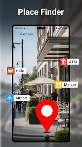
Deep insight into the application's trajectory suggests it serves as a "travel partner" rather than just a map. The "Nearby Places" finder is specifically tuned to highlight essential services such as ATMs, hospitals, gas stations, and restaurants, making it indispensable for long-distance road trips. The historical performance of the app indicates a commitment to accessibility, maintaining compatibility with older Android versions (as far back as 4.4 and 7.0) to ensure a broad user base can access essential navigation tools without upgrading hardware.
Pros
Provides highly accurate, turn-by-turn voice navigation to ensure hands-free driving safety.
Integrated digital speedometer allows for real-time speed monitoring and speed limit alerts.
Multi-utility suite includes live weather updates, a currency converter, and a parking reminder.
Optimized "shortest route" algorithm effectively reduces travel time in traffic-heavy urban environments.
Comprehensive "Nearby Places" locator identifies essential services like hospitals and ATMs instantly.
Flexible visualization layers including Satellite, Hybrid, and Normal map views for better orientation.
Cons
The density of secondary tools within the UI can occasionally lead to a cluttered visual experience.
High dependency on active GPS signals may lead to accuracy issues in dense high-rise urban canyons.
Frequent advertisements in the free version may occasionally interrupt the user’s search flow.
FAQs
While the app focuses on live traffic and real-time updates, it is primarily designed as a connected navigation tool; however, certain versions allow for visited location history tracking.
The user can manually mark their car's GPS coordinates upon parking; the app then saves this location to provide walking directions back to the vehicle later.
Yes, the currency converter uses live exchange rates to assist travelers in managing finances across borders.
The app provides specific route planning and estimated time of arrival (ETA) for cars, bikes, and pedestrians.
Ensure that GPS permissions are enabled and that you have a clear view of the sky, as the speedometer relies on GPS-based velocity calculations.
Hot Reviews
While the app focuses on live traffic and real-time updates, it is primarily designed as a connected navigation tool; however, certain versions allow for visited location history tracking.
The user can manually mark their car's GPS coordinates upon parking; the app then saves this location to provide walking directions back to the vehicle later.
Yes, the currency converter uses live exchange rates to assist travelers in managing finances across borders.
The app provides specific route planning and estimated time of arrival (ETA) for cars, bikes, and pedestrians.
Ensure that GPS permissions are enabled and that you have a clear view of the sky, as the speedometer relies on GPS-based velocity calculations.