
MyRadar Weather Radar


Overview
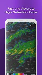
MyRadar Weather Radar is the go-to application for enthusiasts and professionals who demand high-fidelity, real-time atmospheric data. While other apps focus on icons and summaries, MyRadar focuses on the *map*. In 2026, it has solidified its position as a prosumer tool by offering advanced layers such as frontal boundaries, jet stream winds, and hurricane tracking that rival dedicated aviation software.
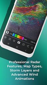
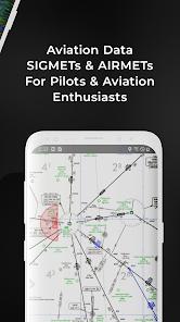
MyRadar's 'Radar Rendering' is significantly faster and smoother. It uses hardware acceleration to loop radar data for up to two hours without stuttering. The 'Aviation Layer' is a standout, providing AIRMETs and SIGMETs, making it a favorite among private pilots. The 2026 update also includes 'Hyper-Local Lightning Detection,' which uses the AccuWeather Lightning Network to provide nearly instantaneous strikes on the map.
The depth of MyRadar is found in its 'Environmental Visualization.' Users can toggle layers for earthquake activity, wildfire tracking, and even satellite imagery. This multi-hazard approach makes it more than just a rain app; it is a comprehensive situational awareness tool. For the average user, the 'Rain in X minutes' notifications are remarkably accurate, but for the power user, the ability to manually scrub through radar snapshots and analyze storm cell movement is where the app truly shines.
Pros & Cons
Extremely fast and smooth radar animations.
Professional-grade aviation and storm tracking layers.
Comprehensive environmental data (wildfires, earthquakes).
Accurate localized precipitation alerts.
- ✕
The interface can feel cluttered due to many toggle options.
- ✕
Some high-end layers require a paid subscription.
Download
FAQs
How do I see the wind speed?
Enable the 'Wind' layer in the settings to see a breathtaking animated representation of surface and jetstream winds.
Does it track hurricanes?
Yes, the Hurricane Tracker provides paths, wind speeds, and projected cones for all active tropical systems.
Is the radar live?
It is near-real-time, with loops showing the last two hours of activity.
Hot Reviews
I've tried them all, and nothing is as smooth as MyRadar. I can see exactly where the storm is moving in real-time.
The AIRMETs and wind layers are essential for my flight planning. It's my secondary nav tool.
The 'rain in 10 minutes' alerts are scarily accurate. It hasn't failed me yet.